- Details
- Parent Category: Въездной туризм
- Published on Wednesday, 03 March 2010 10:59
- Hits: 30856
Tour. SEASON TRAVEL KZ agency offers you to see ancient rock paintings
Petroglyphs River Sazanata
PASSPORT
Hiking trails (ROUTE)
1. Designation of protected areas - Sairam-Ugam SSPE
2. The name of the trail (trail) - Petroglyphs River Sazanata
3. Classification path (route):
1) by type of movement: walking, water, ski, bike, horse, automobile, motorcycle, horse-drawn, combined;
2) at the time of action: year-round, seasonal;
3) in the form of organization: individual and group;
4 (the name of the main geographical areas) Camping STF "Altex" - p. Sayramsu - p. Sazanata - oz. Silbili - headwater Sazanata.
5. The length of the trail - 12 km.
6. Terms functioning path (route) June - September.
7. The maximum number of people in the group, what has caused the restriction (with a capacity of observation platform, psihokomfortnym limit rules recreational pressure, etc.). Limit tour groups a week or a month (recreational load). Not more than 2 groups of 10 people. a week with only 1 Camping grounds.
8. Permitted recreational loads for the various periods in the tour season (if at any time in the season to reduce the load, for example, give peace of mind when birds hatching chicks). Reducing the load up to 5 people. per week should be carried out in June, as this period is the most active period of feeding in red marmots.
9. Ability to complete the trail without a guide. As the trail is marked. What is the need to have of clothing (such as special clothing, if the trail is planned to visit the cave) and shoes (like boots, if there is a risk of wetlands with wet feet, that is, without a special wooden flooring). The trail is marked signs and nameplates. No special equipment is required.
10. Special rules of conduct on the trail (in addition to the general rules of behavior in this protected area, for example, do not go off the path, do not approach the edge of the cliff, observe other precautions).
Petroglyphs are not touched. Do not write on the stones.
11. Security measures. Build a fire in specially equipped centers.
12. The scheme trail (trail) (permitted insert printing of maps and charts published by the scale of at least 1:200,000 with marked trails.
13. Legend: path (route), place of shelter, replacement options, places nights, shelters.
14. A brief description (description) path (route).
15. Brief description of the inspection along the path (route) and observation (review) sites.
The main facilities are included in the itinerary:
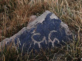
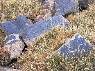
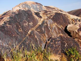
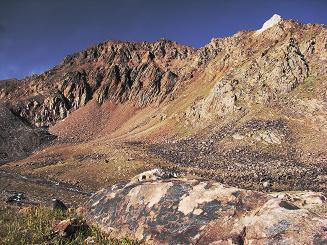
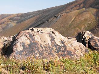
Directions from Shymkent to camping "Altex" (78 km) takes about 2 hours on the bus, so the departure of the city should be implemented no later than 8:00 am. The route starts from the tourist complex "Altex" and runs on a wide and picturesque valley of the river Sazanata. Above turkompleksa good trail goes along the right bank of the river. After 1 hour and 40 minutes is appropriate to merge the two upper tributaries. Sazanata. On the northern slopes of the canyon grow magnificent juniper forests in the floodplain of the river - thick birch grove. After a short rest we continue movement on the right, the left bank of the creek within 35-45 minutes. Here you can eat in a clearing and stock up on water. We pass the river before reaching 100 meters to the canyon. Now the trail is a steep left bank of the south-east. After another 2.5 hours come to the lake Silbili. We stop for a short rest. The route runs along the brightly flowering alpine meadows. Half an hour of movement in the south and the trail leads to a large bivouac clearing in the upper right-hand tributary of the Sazanata. Here stop for the night and a day's rest. Group of petroglyphs is a 15-minute walk from the field on the left bank of the creek. Drawings of animals printed on the flat side of black stones. Care should be taken when inspecting and photographing the petroglyphs - rocks and scree wobbly mobile.
The next day we go down the path of recovery.
16. Brief description of the difficult parts of the trail (route). You should carefully go over the river and gently move the movable stones talus.
17. Possible natural disasters and actions of the group as they occur.
18. Recommendations for the text of a leaflet to the voucher. Makes recommendations regarding hiking equipment, clothes, shoes, behavior, etc. It is recommended to wear a hat for protection from the sun. It is recommended to bring a gas burner or a kerosene stove.
19. Landscaping path (route). Marking. On the trail - indicating the direction and location of Camping grounds. Parking areas, shelters, landscaping path (route) Camping grounds - an observation deck equipped with fireplace.
Ladies and gentlemen, Season Travel Kz organizes a trip to the South Kazakhstan region with visits to ancient cities such as Turkestan and Sairam, Sauran, Otrar and introduce you to the historical and architectural monuments of the Great Silk Road


