- Details
- Parent Category: Въездной туризм
- Published on Thursday, 04 February 2010 08:50
- Hits: 42411
Southern Kazakhstan, Otrar
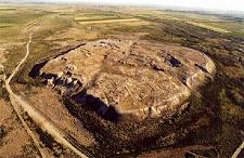
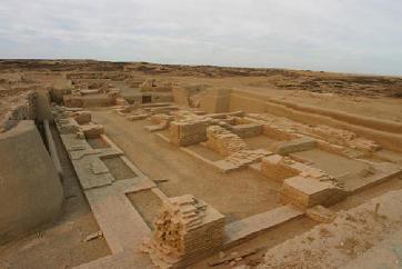
 Otyrar - Otrarsky settlement in the South Kazakhstan region. Settlement is located in the lower reaches of the river Aris where it flows into the Syr Darya River, 10 km to the west of the railway station Timur, near the modern village of Talapty, 57 km south of the city of Turkestan, 120 km north-west of Shymkent. The largest settlement Otrar oasis known as Tarband, Turarband, Turar, Farab. The territory of the oasis adjacent settlement also Kuyruktobe, Kok-Mardan Altyntobe, Mardan-Quick. The heyday of Otrar oasis to the period from I to XIII century AD. The city was inhabited before the beginning of the XIX century. In 1219, he was besieged by the Mongol armies under the leadership of Genghis Khan's eldest son, Jochi. The siege lasted several months. But one night one of the residents opened the gate. The entire population Otyrar had been cut, and the city burned. Traitor is executed personally Jochi. In the XV century, the city was rebuilt, but it was not the same city. The height from the base of the main hill - up to 18 m, the remains of the city moat. Otyrar - the birthplace of the famous medieval mathematician and philosopher al-Farabi. A Otyrar Bibioteka is the world's second book fund after Alexandria. Not far from the fort is the mausoleum of revered Sufi Arystan Baba (Arslan-Bab). According to historical sources, after there had been executed the ambassadors of Genghis Khan, the city was destroyed by the Mongols in 1219, with the majority of the inhabitants were killed. However, in the cultural layers otnosyaschhsya settlement to the XIII century traces of strong fires and destruction, almost found the destruction suffered only citadel of the city. In January 1405 Utrar in the beginning of his campaign to China, Timur died. Surface of the city is rough, almost entirely covered with the debris of bricks, ceramic slag, fragments of irrigation and unglazed pottery. Central, main, street crosses the fort gate and connects the southern and north-eastern walls. It is almost straight and is clearly apparent in the topography of the monument in the form of a trough width of 12 m away and at right angles aside in the streets that run into the wall. They are in turn branch off small lanes and alley and divide the territory of the settlement nakvartaly different area. To the central hillock adjacent settlement of land, surrounded by a wall, which is clearly visible on aerial photographs, while the area shows only its parts. On the northwest side of the wall is the modern village. It is located slightly below the fort. This wall has two rectangular protrusions, apparently, due to the natural terrain. Most of its remoteness from the northern corner of the ancient city - 520 m wall is well preserved and is a oplyvshy shaft width of 20-25 m and a height of 3.5 meters outside the moat in some areas waterlogged. Its depth of 2 m, width of 10-15 m noticeable gap in the wall (width 10 m), there was entry. According to it, and is currently undergoing field in Shaulder. Near the entrance are the remains of buildings in the form of a rectangular mound. In turn, he dissected by narrow grooves on several hillocks, which seem to correspond to the old layout of the streets. In good condition eastern portion of the outer wall. From inside adjoin building blocks separated by two intersecting streets. The greatest distance from the east wall - 750 meters, measured from the middle of the eastern wall of the main hill. The southern section of the shaft remained bad. Here is plowed land settlement. On an aerial photograph of the shaft direction unmasked light strip. South fort stretches for 500 meters, counting from the entrance to the most remote point of the outer shaft. On the west side of the outer shaft is almost destroyed. From left several buildings flattened mounds of various configurations and sizes. At the southern wall of the main hill at a distance of 80-100 meters preserved waisted trench with walls dropping smoothly. He is now overgrown with grass. This former water reservoir. It was filled with water from the main canal. Inside rabad had extensive gardens, which are reported in the "Anonymous Iskander" in describing the scene of a power struggle Timur and Urus Khan. Timur sent to Otyrar one of the military leaders to get first, the last, meeting in Utrar soldiers Urus Khan, "among the houses and gardens laid an ambush." Unfortunately, the sources contain very little specific information about the topography of Otyrar, and therefore the nature of development has been clarified in the course of excavation. Studies over Otyrar carried the XIX century. Since 1971,
 begin the study of the South Kazakhstan complex expedition, which has worked so far, with breaks in 1993-1996. Over the years, the Utrar opened at the level of XVI-XVIII centuries. land settlement in the area of about 7 hectares, as well as some areas explored areas of the Timurid period, karaganid. From 2001 to 2004, conducted comprehensive studies Otyrar under the auspices of UNESCO, the Japan Trust Fund-Kazakhstan "Conservation and restoration of the ancient Otrar."
Ladies and gentlemen, Season Travel Kz organizes a trip to the South Kazakhstan region with visits to ancient cities such as Turkestan and Sairam, Sauran, Otrar and introduce you to the historical and architectural monuments of the Great Silk Road.


